Full Ecological Report
A deep dive into the ecological details and background of Dows Lake
Introduction
Cities tend to be built on rivers for the many services that they provide; they offer freshwater, transportation, and fertile soils, but these services are threatened by the destruction of riparian zones for urban development. River shorelines form a unique type of habitat on the water’s edge that is essential to riparian species and maintaining the health of rivers (Groffman et al., 2003). At Dow’s Lake we are hoping to restore these shorelines by removing invasive species and planting lawns that will be replaced with native species, reducing shoreline erosion and filtering polluted runoff while forming viable habitat for native wildlife. Restoring these ecosystems will benefit all stakeholders including plants, animals and people. A restored shoreline at Dow’s Lake will create a refuge for wildlife, and provide critical services for the people living in the area, or those who enjoy walking, biking and connecting with nature in these spaces.
Anatomy of a Riparian Zone
Riparian zones are typically discussed in terms of distance from the water, with different structures and functions making up the system at different distances. Thicker riparian zones accumulate these different structures and functions and provide a more diverse habitat with a wider range of services provided. This project will focus on the distances of 5, 10, 20, 30 and 50 metres for the purpose of simplifying the human element of restoration, although in practice, as the system becomes self-sustaining, these borders will blur and the different zones will become interdependent.
At 5m, the riparian zone typically includes reeds along the water’s edge and some (typically smaller) land vegetation like grasses, wildflowers and shrubs, depending on the ecosystem. This buffer width provides basic erosion control, sediment filtration and organic matter, significantly increasing the ecological value of the shoreline compared to a minimal or absent buffer. From 5-10m, the buffer gains less services and functions but the vegetation shifts away from plants that must be right on the waterside to more terrestrial vegetation. As the buffer approaches 20 meters, these services are increased while also beginning to act as a nutrient filter, reducing runoff of nitrogen and phosphorus into the water. Vegetation in the 10-20m zone is again, dependent on the ecosystem, but is typically larger than the 0-5m zone and includes more woody vegetation (Lind et al., 2019).
Beyond 20 metres, the riparian zone develops significantly more ecological function. A 30m buffer can typically filter nutrients and sediments, hold back erosion, and maintain significant biodiversity of vascular plants, insects, and fish. By 30 metres, the riparian zone will usually entail significant woody vegetation and a canopy layer that can provide shading to the water. A 50 metre buffer zone surrounding the water is the target set for most of this project, which is similar in vegetation to the 20-30m zone, but then approaches a wide enough buffer to maintain diversity of small mammals and amphibians. This is particularly important given that amphibians are the most threatened group of animals, and their dependence on water makes them largely dependent on healthy riparian zones (Lind et al., 2019).
These structures and services offered by the riparian zone at each of these distances can of course differ depending on various other factors as well. Highly sloped buffers may require more woody vegetation or greater distances to filter nutrients and sediments sufficiently. Wide, unmanaged buffers may have disturbance regimes impacting vegetation structures, such as intermittent floods, wildfires, or the presence of keystone species like beavers that tear down woody vegetation and dam flowing waters (Mohan & Joseph, 2024). No two riparian zones are the same, so while these set distances provide a framework for restoring or studying a shoreline, the ecosystem should be permitted to change naturally, and ongoing restoration efforts should be adjusted to the natural progression of the system (Hodge & Adams, 2016).
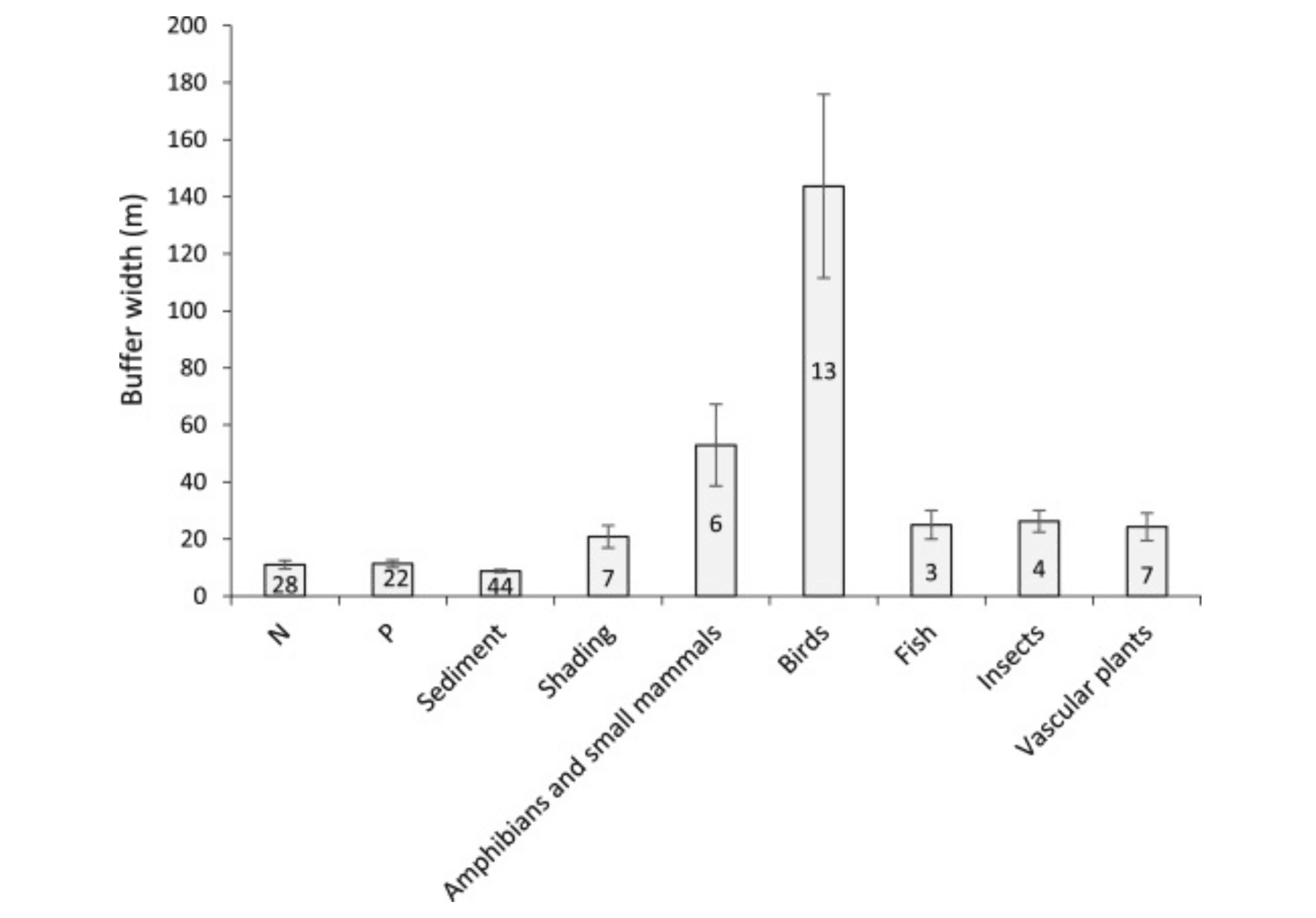
Figure 1. Buffer width for ecosystem functions of biodiversity maintenance, shading, nutrient filtration and sediment filtration. Reproduced from a meta-analysis of papers containing quantitative recommendations for buffer widths, reproduced from Lind et. al., (2019). Data are mean +/- SE, sample size indicated on the bars.
Plant Species to be Included
A key solution to restore the riparian zones around Dow’s Lake is planting native species that reduce the effects of soil loss and erosion. Planting vegetation native to Ontario can be beneficial to the bank for several reasons: root systems of plants hold soil particles together and help it withstand wind and water erosion, absorb excess water from the lake and reduce flooding occurrences, and overall contribute to the biodiversity of the area which in turn also reduces soil loss and erosion.
Oak trees have deep and strong root systems that extend over great areas. These roots promote soil stabilization by holding particles in place and protect against soil loss from water or wind erosion. Surface runoff is also controlled by the root system as they have a greater ability to absorb precipitation. Additionally, the canopy of oak trees cover large areas and protect more soil from the impact of precipitation. Leaf litter that falls from the canopy contributes to enriching the soil with nutrients and protects microenvironments. Examples of oak trees native to Ontario that are key to reducing soil erosion along slopes and banks are Red Oak (Quercus rubra), Bur Oak (Quercus macrocarpa), and White Oak (Quercus alba).
Other trees with similar properties to Oak trees include sugar maple trees and white pines. They are both keystone species in Ontario and of the forests of North America. They provide habitats to birds, insects and small mammals, contribute to the nutrient cycle, and have deep root systems.
Other effective plant species such as Forsythia reduce soil erosion on slopes by their strong root system making them a perfect match to be planted along the bank of Dow’s Lake. They are also characteristically known for their bright flowering petals that attract pollinators such as insects to the area. Other essential plants for soil loss reduction include Black eyed Susan, Large fruited bur reed, Bebb’s Sedge, Virginia Creeper, American Ginseng, and Buttonbush. These listed species also provide food and habitat while contributing to the biodiversity of the environment.
Invasive Species
There are some aggressive invasive species that pose a threat to Ottawa’s Dow’s Lake area such as reed-grasses like Phragmites. The Nature Conservancy of Canada (NCC) states that phragmites is Ontario’s worst invasive species and is taking over wetland environments, outcompeting other native biodiversity. Phragmites is originally from Eurasia but is quickly dominating North America. Once introduced, the roots spread extensively over the area as its rhizomes act as a large network. This is problematic as native plants and overall biodiversity are being reduced, other animals such as frogs and turtles lose habitat and nutrient availability. It is important to distinguish invasive phragmites with native phragmites. Native phragmites have reddish-brown stems and yellow-green leaves unlike its invasive counterpart that features tan-beige stems and blue-green leaves.
The Ministry of Natural Resources and the NCC have partnered to combat the invasive species. In most areas in Ontario, the spread is so severe that no other life can propagate and the only solution would be to use a Health Canada and EPA-approved herbicide. This is not the most effective solution to be used in the Dow’s Lake area, as the initiative is to protect other plant species as well. Other ways to help mitigate this issue are by manualling controlling the propagation by hand pulling or digging. Biological methods may also be of use by carefully introducing moth species such as Archanara neurica and Lenisa geminipuncta whose caterpillars control the growth and spread of phragmites by feeding on the plant. These caterpillars only target and eat the invasive phragmites stems and not other species, which is a critical aspect to biological control methods for invasive species. The removal option that we choose to be most effective is to smother the phragmites near Dow’s Lake with a large, thick black fabric to prevent solar energy from reaching the plants. This method will effectively reduce growth and remove phragmites from the area without harming other biodiversity in the area.
There are other aggressive invasive species in this area such as Purple Loosestrife, Honeysuckle, Japanese Knotweed, and more that can be eradicated in similar ways. The Government of Canada poses management steps to take when combating aquatic invasive species: (i) preventing the arrival of the potentially invasive species (ii) early identification the moment of introduction and when a population has been established (iii) responding with methods for species eradication and restoring the habitat to its pre-invasion state and finally (iv) control and management to further mitigate the impact of an aquatic invasive species. Additionally there are outlined plans for ways specific individuals can stop the spread of invasive species such as cottagers action plan, gardeners action plan, hikers action plan, and more.
Restoration of the North Shore
The first shoreline restoration phase and the smaller of the two is the north shore of Dow’s Lake. The North Shore Restoration is about 4 hectares of primarily lawn/park area in between Dow’s Lake and Queen Elizabeth Driveway. Most of the length of this section will be restored to 30-50 metres, with areas closer to each end being narrower. While this area is largely city-owned green space, the shoreline is held back by a retention wall as part of the Rideau Canal. We would recommend removing the wall before any restoration begins and allowing soils to settle to some extent, then planting fast growing plants with extensive root systems to stem erosion. With the canal being a UNESCO World Heritage Site, this is likely infeasible so restoration must be done as well as possible under these circumstances.
The next step is the extermination of lawn grasses. Most of the north shore is covered with non-native lawn grasses that are resilient, competitive and will hinder the growth and function of the native species to be restored. There are two approaches to this task that are practical at a large scale, herbicides and tillage. Neither are particularly eco-friendly, with tillage drying out soils and destroying microbial communities in the soil, and herbicide introducing persistent pollutants to the ecosystem that will inevitably enter the waterway (Mehdizadeh et al., 2021). It is our recommendation that the grass is tilled under and the soil rolled in order to avoid the introduction of new chemicals into an already polluted urban water system. Following this, the plants listed later in this plan are to be planted according to distance from the shore. The asphalt walkways already present will remain in place, with added streetlamps for user safety due to the additional darkness from the shade of the growing trees. The lamps will have shades directing all light directly downward to the walkway and only be on during dark waking hours to minimize light pollution (Gaston et al., 2012). These narrow walkways are not expected to pose any significant ecological problem for the proposed project.
Restoration of the South Shore (Dominion Arboretum)
The second phase of the Dow’s Lake restoration project is the southern shore of the lake. This area is about 6 hectares of land belonging to Agriculture Canada as part of the Dominion Arboretum. This project will restore up to 50 metres of buffer zone for nearly the full length of this section. This area will include some of the marsh land just past the Dow’s Lake Peninsula, and the peninsula itself; it will go around the pump house near the lake. Riparian restoration for this phase is like the plan outlined above, but with a few key differences. The first is that apart from a large storm drain, the shoreline is free of concrete walls. The first step here is not to address the walls like on the north side of the lake but the large rocks placed along the shore to stabilize the banks. These rocks will have to be removed by truck, to make way for any significant vegetation to grow on the banks. The lack of walls along this shoreline will also allow for more of the animal habitat efforts described below to be implemented. Another difference is the presence of rare and exotic trees that are part of the arboretum’s collection. These trees are non-native but not invasive either, and will be left where they are with little negative ecological impact in cooperation with the arboretum. The removal of invasive species and the planting of natives is similar to the north side, as well as the plan for walkways and streetlamps.
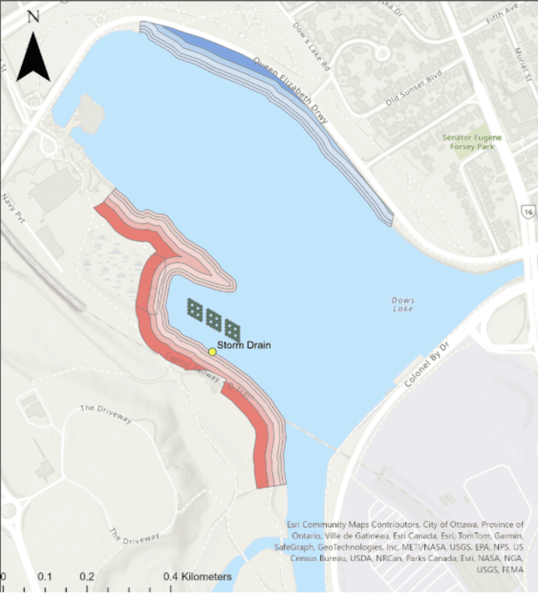
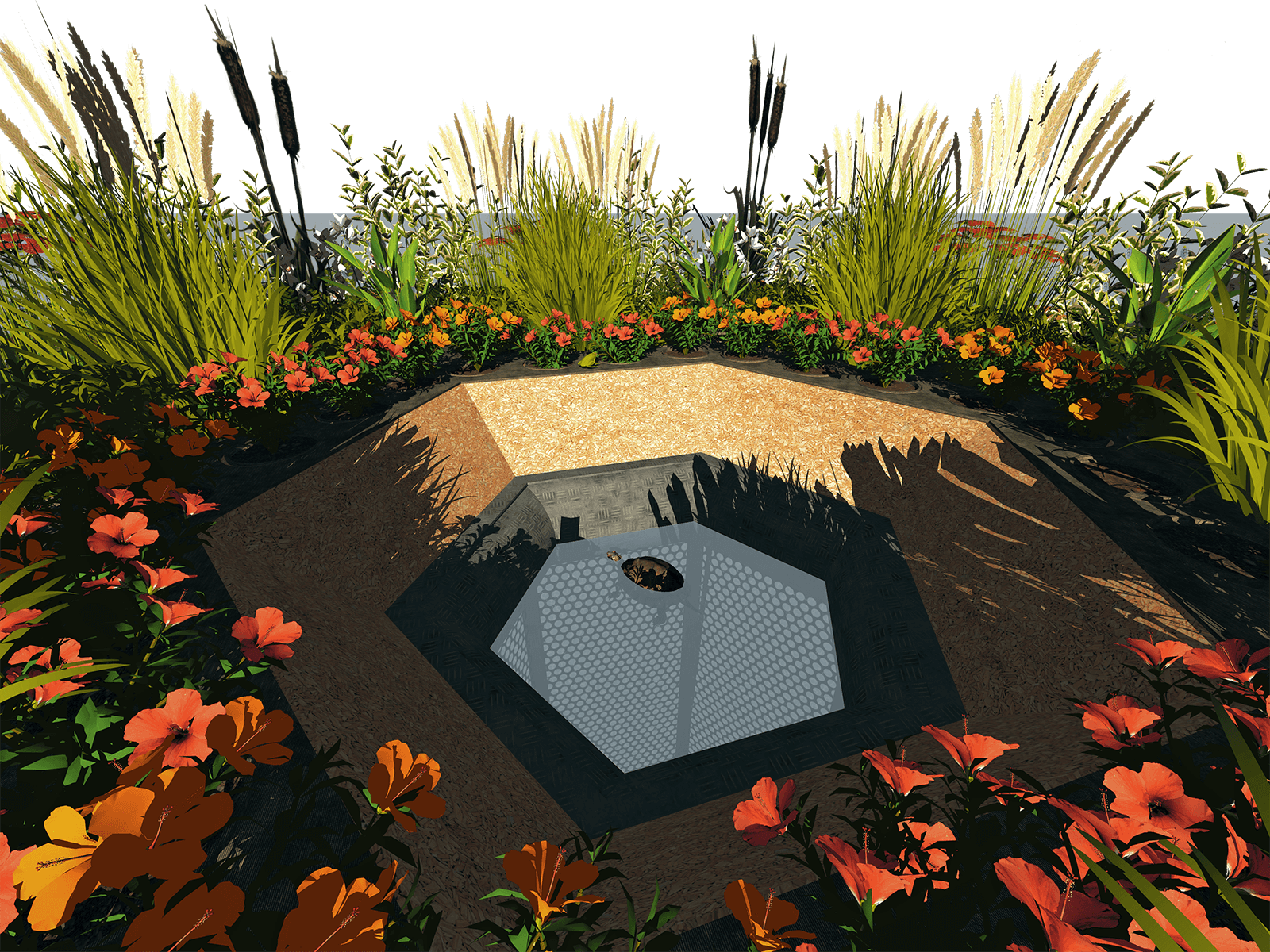
Figure 2. Dow’s Lake Restoration Proposal Map. North Shore Restoration (blue) and South Shore Restoration (red) have graduated colour schemes representing 5, 10, 20, 30, and 50 metre riparian buffers. Sixty-three floating treatment wetland units to cover approx. 7% of the afflicted area are in green and organized perpendicularly to the storm drain outflow. Layout of FTWs is for artistic value and sufficient water aeration. Each unit is a regular hexagon with side lengths of 4.5m. Created in ArcGIS Pro 3.2.
Animal Habitat Efforts
Dow’s Lake is surrounded by urban development, so many animal species have been extirpated from this area. This project will include specific measures to facilitate successful reintroduction and rehabilitation of these animals, while considering the risk of creating an ecological trap. An ecological trap is a habitat that looks more appealing to an animal population than it is suitable (Mckercher et al., 2023). This can be avoided by making the habitat look unappealing, or by making it genuinely suitable; we propose the latter.
To do this we will restore shorelines and implement floating wetlands to improve water quality and make it adequate for fish, insects and amphibians to lay their eggs. Soil will be left uneven after tilling the grass to allow springtime ephemeral pools to form and improve habitat for amphibians and insects (Semlitsch & Bodie, 1998). Shoreline will be gently sloped to create nesting grounds for turtles and waterfowl, and these areas will be monitored and protected from human disturbance, integrating community adaptive management practices (Hodge & Adams, 2016). Wildflowers will be planted in buffer zones closer to the shore to attract and support pollinators like threatened species of bee. Detritus and fallen branches will be allowed to accumulate in the water near the shore to create attachment points for molluscs, refuges for fish and basking areas for turtles (Gurnell et al., 2002). With a combination of these efforts, we hope to attract species that are now very rarely found in urbanized areas, and to adequately support them when they arrive.
Past Examples of Shoreline Restoration in Ottawa
Shoreline restoration projects have been carried out around the world to improve water quality and bolster biodiversity, some of these projects have served as direct inspiration for the proposed Dow’s Lake Restoration. Within the Ottawa area, there are examples of the City already undertaking river shoreline restoration projects for functionality and ecosystem services like in the Ruisseau Park Ravine project currently underway in Orleans (City of Ottawa, 2022). The City has also assisted in projects expressly purposed for the maintenance of biodiversity in and of itself, like the 2016-18 Carp River Rehabilitation project led by the Mississippi Valley Conservation Authority (MVCA) (Friends of the Carp River, 2021). Both of these examples illustrate how healthy riparian ecosystems can coexist with adjacent suburban and urban environments in a way that benefits all stakeholders.
The Ruisseau Park project focused primarily on controlling erosion for the benefits of people and property surrounding the valley. By planting native vegetation, and integrating engineered solutions like weir pools, the project improves habitat conditions for local wildlife and the overall health of the ecosystem while reestablishing necessary services. While the Ruisseau Park rehabilitation falls lower along the Restorative Continuum and only exists out of human need, it demonstrates the integral use of nature-based solutions to maintain a functional relationship between urban and natural environments (City of Ottawa, n.d.). It is in this light that the Dow’s Lake proposal aims to combine engineered solutions like FTWs with a renaturalized shoreline to restore essential ecosystem services to the area.
The MVCA, as a conservation authority, took the opposite approach and focused on the ecosystem first, adding anthropocentric features afterwards. With extensive help from local volunteers, the project planted thousands of native plants and restored a floodplain/wetland riparian buffer along a 4km stretch of the Carp River in Kanata (MVCA, n.d.). Research and preparation for this restoration was based on current ecological understandings of best practices, with the goal of restoring the area to its native state before the dredging and channelization of the early 1900s (Friends of the Carp River, 2021). This length of the Carp River is now a local biodiversity hotspot, with walking trails and educational information accessible for public enjoyment (MVCA, n.d.). The Carp River Restoration provides an excellent example for the Dow’s Lake team of how to revive native ecosystems while including existing communities in the creation, enjoyment, and adaptive management of the system.
Dow’s Lake on the SER Restorative Continuum
The shoreline restoration phases of the Dow’s Lake project will progress through several phases of the Society for Ecological Restoration’s restorative continuum (Gann et al., 2019). While the grass is being tilled and walls of rocks are being removed, the project “reduces societal impacts” by minimizing further direct harm to the environment. Removing native species and monitoring for future infestations are examples of “improving ecosystem management” and begins the remediation process. Then plants are set into the freshly turned soil, “initiating native recovery” by rehabilitating the ecosystem and providing the necessary ingredients for the system to become resilient and self-sufficient with time. All of this within the first year or two. Further down the road, in perhaps 5-10 years and increasingly over time, these shorelines will be “partially recovering native ecosystems” with animals taking refuge in the pocket of restored habitat and sustainable ecosystem services being derived from ecosystem structures closely approximating a native shoreline. Unfortunately this is the best that can reasonably be hoped for in this project. Dow’s Lake (formerly Dow’s Great Swamp) will never again be a sprawling wetland without the destruction of large swaths of the City of Ottawa. Although we cannot have a “fully restored native ecosystem” the partial ecological restoration of Dow’s Lake would be considered a success as an example of how humans can integrate urban life and healthy ecosystems together for a more sustainable future (Gann et al., 2019).
Shoreline Restoration Metrics
In conjunction with the monitoring of floating treatment wetland monitoring, shoreline restoration monitoring will also be done three times a year (spring, summer, fall) using the same seasonal format as stated in the floating wetland section. In addition to water quality monitoring, other significant indicators of shoreline restoration success include decline in invasive species presence, establishment of planted species, erosion rates, and presence of wildlife. These are also monitored during the same three time intervals.
For invasive species, visual identification will be conducted to determine if they are still present and if smothering or removal has been effective. Surveillance allows for the detection of any resurgence and informs for future management actions. Also, newly planted species are tracked to assess if they are surviving. Plant health can be quantified with growth metrics such as stem diameter and plant height, and through signs of disease and stress.
Erosion rates are a critical component of shoreline restoration, especially given the seasonal stress of ice movement and springtime runoff. Measurements will be taken in the spring once to gauge the extent of erosion following winter, and once in fall to measure the extent of the root systems of the established species. Erosion is calculated by tracking the changes in the exposed length of erosion pins after they have been inserted into the ground at a known length (Kearny et al., 2018). These offer a comparison to understand how the shoreline is recovering and if vegetation is mitigating soil loss.
Furthermore, wildlife presence is recorded throughout the year to track seasonal patterns and biodiversity. Observations of bird species, insects, amphibians, and aquatic life serve as a useful ecological indicator of habitat quality and restoration success. Their presence serves as a bioindicator to the conditions of the environment, for example, the presence of more insects can indicate an increase in water quality (Chowdhury et al., 2023).
For proper and representative data collection, the monitoring of the water quality will be done at 3 to 5 locations along both the north and south shorelines. For non-water quality parameters, the monitoring will be done along the buffering zones where species are planted along both the north and south shorelines.
References
About Aquatic Invasive Species. Government of Canada, (2024, December 4). Fisheries and Oceans Canada, Communications Branch. https://www.dfo-mpo.gc.ca/species-especes/ais-eae/about-sur/index-eng.html#species
Akinnawo, Solomon Oluwaseun. (2023) Eutrophication: Causes, consequences, physical, chemical and biological techniques for mitigation strategies. Environmental Challenges. Volume 12. https://doi.org/10.1016/j.envc.2023.100733.
Anjos, O., Rodrigues, C., Morais, J., & Pereira, H. (2014). Effect of density on the compression behaviour of Cork. Materials & Design, 53, 1089–1096. https://doi.org/10.1016/j.matdes.2013.07.038
Blue-green algae. ontario. (n.d.). https://www.ontario.ca/page/blue-green-algae#:~:text=Blooms%20are%20most%20common%20in,calm%20water
Byanju, A., Pradhanang, S., & Pradhananga, D. (2024). Guidebook Floating Treatment Wetland System (FTWS). Retrieved from https://www.apn-gcr.org/wp-content/uploads/2024/06/CRRP2021-11MY-P.Kayastha-Guidebook.pdf?
Carp River Conservation Area. MVCA. (n.d.). https://mvc.on.ca/conservation-areas/carp-river/
Carp River Restoration Project 2016-2018: Friends of the carp river. Friends of the Carp River | Volunteers dedicated to restoring the ribbon of life along the Carp River. (2021, July 9). https://friendsofthecarpriver.com/carp-river-restoration-area-2016-present/
Chowdhury, S., Dubey, V. K., Choudhury, S., Das, A., Jeengar, D., Sujatha, B., Kumar, A., Kumar, N., Semwal, A., & Kumar, V. (2023). Insects as bioindicator: A hidden gem for environmental monitoring. Frontiers in Environmental Science, 11. https://doi.org/10.3389/fenvs.2023.1146052
Daigle, J.-Y., Gautreau-Daigle, H., & Keys, D. G. (2001). Canadian peat harvesting and the environment. North American Wetlands Conservation Council (Canada). https://nawcc.wetlandnetwork.ca/Can%20Peat%20Harvesting%202001-1.pdf
Edwards, T. (2025, February 19). Cedar Woods Remarkable Weather Resistance. Wagner Meters. https://www.wagnermeters.com/moisture-meters/wood-info/cedars-remarkable-weather-resistance/?srsltid=AfmBOopHAvELmcf207omsmSQ9YpL3KDz2fsqIBrdy2rdhpr5KpF5dGKS
Fighting Phragmites - Ontario’s worst invasive species. NCC: Where We Work - Ontario. (n.d.). https://www.natureconservancy.ca/en/where-we-work/ontario/our-work/stewardship/fighting-phragmites.html
Gann, G. D., McDonald, T., Walder, B., Aronson, J., Nelson, C. R., Jonson, J., Hallett, J. G., Eisenberg, C., Guariguata, M. R., Liu, J., Hua, F., Echeverría, C., Gonzales, E., Shaw, N., Decleer, K., & Dixon, K. W. (2019). International principles and standards for the practice of ecological restoration. Second edition. Restoration Ecology, 27(S1). https://doi.org/10.1111/rec.13035
Gaston, K. J., Davies, T. W., Bennie, J., & Hopkins, J. (2012). Review: Reducing the ecological consequences of night‐time light pollution: Options and developments. Journal of Applied Ecology, 49(6), 1256–1266. https://doi.org/10.1111/j.1365-2664.2012.02212.x
Groffman, P. M., Bain, D. J., Band, L. E., Belt, K. T., Brush, G. S., Grove, J. M., Pouyat, R. V., Yesilonis, I. C., & Zipperer, W. C. (2003). Down by the Riverside: Urban Riparian Ecology. Frontiers in Ecology and the Environment, 1(6), 315. https://doi.org/10.2307/3868092
Gupta, V., Courtemanche, J., Gunn, J., & Mykytczuk, N. (2020). Shallow floating treatment wetland capable of sulfate reduction in acid mine drainage impacted waters in a northern climate. Journal of Environmental Management, 263. https://doi.org/10.1016/j.jenvman.2020.110351
Gurnell, A. M., Piegay, H., Swanson, F. J., & Gregory, S. V. (2002). Large wood and fluvial processes. Freshwater Biology, 47(4), 601–619. https://doi.org/10.1046/j.1365-2427.2002.00916.x
Hodge, I., & Adams, W. (2016). Short-term projects versus adaptive governance: Conflicting demands in the management of ecological restoration. Land, 5(4), 39. https://doi.org/10.3390/land5040039
Hofmann, T., Visi-Rajczi, E., Bocz, B., Bocz, D., & Albert, L. (2020). Antioxidant capacity and tentative identification of polyphenolic compounds of cones of selected coniferous species. Acta Silvatica et Lignaria Hungarica, 16(2), 79–94. https://doi.org/10.37045/aslh-2020-0006
Hopwood, J. L. (2008). The contribution of roadside grassland restorations to native bee conservation. Biological Conservation, 141(10), 2632–2640. https://doi.org/10.1016/j.biocon.2008.07.026
Invasive species in Ontario. ontario.ca. (n.d.). https://www.ontario.ca/page/invasive-species-ontario
Kearney, S. P., Fonte, S. J., García, E., & Smukler, S. M. (2018). Improving the utility of erosion pins: Absolute value of pin height change as an indicator of relative erosion. CATENA, 163, 427–432. https://doi.org/10.1016/j.catena.2017.12.008
Landon, M., & Hunt, W. (2020). Installation and Maintenance of Floating Treatment Wetlands: A Guide on Retrofitting Stormwater Retention Ponds in North Carolina | NC State Extension Publications. Retrieved April 2, 2025, from Ncsu.edu website: https://content.ces.ncsu.edu/installation-and-maintenance-of-floating-treatment-wetlands?
Lee, S. Y., Maniquiz, M. C., Choi, J. Y., Jeong, S. M., & Kim, L. H. (2013). Seasonal nutrient uptake of plant biomass in a constructed wetland treating piggery wastewater effluent. Water Science and Technology, 67(6), 1317–1323. https://doi.org/10.2166/wst.2013.002
Lewis, Justin. Three Keystone Trees of Ontario's Forests. LEAF. (14 Jan, 2025) www.yourleaf.org/blog/justin-lewis/jan-14-2025/three-keystone-trees-ontarios-forests
Lind, L., Hasselquist, E. M., & Laudon, H. (2019). Towards ecologically functional riparian zones: A meta-analysis to develop guidelines for protecting ecosystem functions and biodiversity in agricultural landscapes. Journal of Environmental Management, 249, 109391. https://doi.org/10.1016/j.jenvman.2019.109391
Local Enhancement & appreciation of forests. LEAF. (n.d.). https://www.yourleaf.org/
McKercher, L. J., Kimball, M. E., Scaroni, A. E., White, S. A., & Strosnider, W. H. (2023). Stormwater Ponds serve as variable quality habitat for diverse taxa. Wetlands Ecology and Management, 32(1), 109–131. https://doi.org/10.1007/s11273-023-09964-x
Mehdizadeh, M., Mushtaq, W., Anusha Siddiqui, S., Ayadi, S., Kaur, P., Yeboah, S., Mazraedoost, S., K.A.AL-Taey, D., & Tampubolon, K. (2021). Herbicide residues in agroecosystems: Fate, detection, and effect on non-target plants. Reviews in Agricultural Science, 9(0), 157–167. https://doi.org/10.7831/ras.9.0_157
Mohan, N.S., & Joseph, S. (2024). Disturbances on riparian vegetation: A comprehensive review. International Journal of Research and Review, 11(4), 200–208. https://doi.org/10.52403/ijrr.20240422
Monitoring Lake Water Quality: Lakeshore Capacity Assessment Handbook: Protecting Water Quality in inland lakes. Ontario. (n.d.). https://www.ontario.ca/document/lakeshore-capacity-assessment-handbook-protecting-water-quality-inland-lakes/monitoring-lake-water-quality
Read, J., Fletcher, T. D., Wevill, T., & Deletic, A. (2009). Plant traits that enhance pollutant removal from stormwater in biofiltration systems. International Journal of Phytoremediation, 12(1), 34–53. https://doi.org/10.1080/15226510902767114
Removal Effect of Pollutants from Stormwater Runoff in Shallow Bioretention System with Gramineous Plants. Water Science & Technology, vol. 89, no. 8, 2024, pp. 1946–1956. IWA Publishing, doi:10.2166/wst.2024.101543.
Ruisseau Park Ravine (blue willow park) rehabilitation – phase 1: Class Environmental Assessment (EA) and functional design. City of Ottawa. (2022, August 16). https://ottawa.ca/en/city-hall/public-engagement/public-engagement-project-search/ruisseau-park-ravine-blue-willow-park-rehabilitation-phase-1-class-environmental-assessment-ea-and-functional-design#
Ruisseau Park Ravine Rehabilitation | City of Ottawa. Ruisseau Park Ravine Rehabilitation Class Environmental Assessment. (n.d.). https://documents.ottawa.ca/sites/default/files/ruisseau_ea_public_meeting.pdf
Semlitsch, R. D., & Bodie, J. R. (1998). Are small, isolated wetlands expendable? Conservation Biology, 12(5), 1129–1133. https://doi.org/10.1046/j.1523-1739.1998.98166.x
The role of trees in erosion prevention and soil conservation. Trees in Erosion Prevention and Soil Conservation | Tree Doctors Inc. (2023, September 11). https://treedoctors.ca/the-role-of-trees-in-erosion-prevention-and-soil-conservation#:.
Two moth species now in the fight against invasive phragmites. Ducks Unlimited Canada. (2024, August 2). https://www.ducks.ca/news/provincial/ontario/two-moth-species-now-in-the-fight-against-invasive-phragmites/#:~:text=In%20the%20case%20of%20weed,stems%2C%20not%20other%20plant%20species.
Wang, C.-Y., Sample, D. J., Day, S. D., & Grizzard, T. J. (2015). Floating treatment wetland nutrient removal through vegetation harvest and observations from a field study. Ecological Engineering, 78, 15–26. https://doi.org/10.1016/j.ecoleng.2014.05.018
White, S. A., & Cousins, M. M. (2013). Floating treatment wetland aided remediation of nitrogen and phosphorus from simulated stormwater runoff. Ecological Engineering, 61, 207–215. https://doi.org/10.1016/j.ecoleng.2013.09.020
Jing Yang, Hui Luo, Huiteng Wang, Teng Qin, Mingyu Yang, Limin Chen, Xi Wu, Bao-Jie He; Removal effect of pollutants from stormwater runoff in shallow bioretention system with gramineous plants. Water Sci Technol 15 April 2024; 89 (8): 1946–1960. doi: https://doi.org/10.2166/wst.2024.111